28th Jul, 2021 10:30 GMT/BST
Books, Maps & Manuscripts


8
Ogilby (John). The Continuation of the Road from London to Barwick, beginning at Tuxford and...
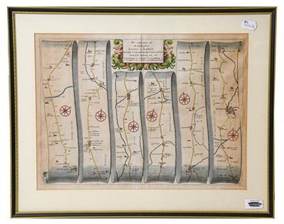
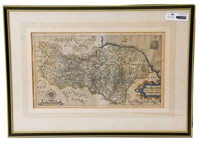
Ogilby (John). The Continuation of the Road from London to Barwick, beginning at Tuxford and extending to York. Plate 3d ... From Tuxford to Bawtre ... Doncaster ... Wentbridge ... Tadcaster ... York, [and:] The Continuation of the Road from London to Barwick beginning at York and extending to Chester in ye Street. Plate ye 4th ... Burrowbridge ... to Topcliff ... Northallerton ... Darlington ... Durham ... Chester in ye Street, [1675 or 1698]. 2 hand-coloured engraved strip road maps, somewhat browned, separately mounted, framed and glazed, mount apertures 345 x 466 mm, together with: Saxton (Christopher). Eboracensis comitatus pars septentrionalis vulgo North Riding [of Yorkshire]. Gulielmus Hole sculpsit, [1607]. Hand-coloured engraved map, mounted, framed and glazed, mount aperture 210 x 362 mm (qty: 3) Cf. Chubb C-CIIa (Ogilby) and XVIII (Saxton; the map is from William Camden's Britannia).
Sold for £160
Estimated at £50 - £80
Auction: Books, Maps & Manuscripts, 28th Jul, 2021
Books, Maps & Manuscripts
Sell one like this
If you've got a similar item to sell, complete the valuation form below and one of our experts will get in touch.

